Tuesday, October 4, 2016

University Place Presbyterian Church


Looking over my notes on Elizabeth Kane's 1853 journal, I found some information about her marriage.  She & Thomas were married on April 21, 1853 at the Presbyterian Church on 10th Street & University Place, New York City.  I put the address in Google Maps to see if it was still there (it isn't), then I googled "10th street and university place presbyterian church nyc" and found this:

http://www.nycago.org/Organs/NYC/html/UniversityPlacePres.html

It is all about the organ at University Place Presbyterian Church, but it has a picture, & tells me that the Church stood on the southeast corner of 10th & University Place.  After some (3, I think) of the Presbyterian congregations in New York City combined in 1918, the church was demolished.

Monday, April 11, 2016

Big Horn Stake Relief Society

Last month (March 17th) was the 174th anniversary of the founding of the Relief Society, first called the "Female Relief Society of Nauvoo."  It's so awesome that the original minute book has been digitized and is now available online
https://history.lds.org/article/women_in_church_history_research_guide?lang=eng

First page of the Relief Society Minute Book
So this minute book is pretty famous among Mormon historians.  After the Mormons were driven out of Nauvoo, the Relief Society stopped meeting.  It was reestablished in 1867, with Eliza R. Snow as President.  She had been secretary of the Nauvoo R.S., and this minute book was hers.  She used her minute book to help the various Relief Society groups throughout Utah and other colonies and use it as a guide to their new fledgling groups.

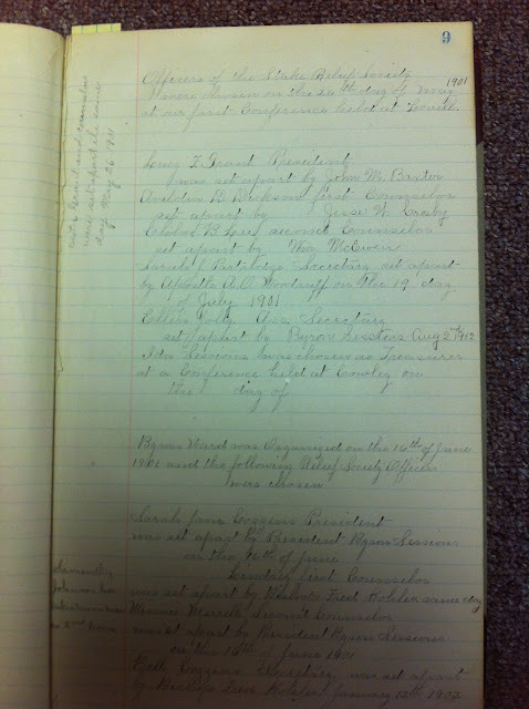
To honor the anniversary of Relief Society and the availability of the Nauvoo Relief Society minute book, I thought I would share my own exciting find.  The minutes of the Big Horn Stake (Wyoming) Relief Society!

k
The Big Horn Stake Relief Society was organized in May 1901, one year after Mormon settlers from Utah and Idaho began arriving in the Big Horn Basin.  I was so excited to find this primary source document at the Cowley Museum last summer.  They also have the Lovell Ward Relief Society Minutes.  

It was fun to see names I recognize; many of these women's descendants still live in the Big Horn Basin.  I even saw my own great-grandmother's name: Eliza Asay!  I think she offered a prayer or something.  It's been a while since I saw it.

I took pics of every page, and I was going to post more pictures, but some of them are sideways & I can't figure out how to turn them right in blogger.


Friday, March 11, 2016

Historical Site: Wagon Ruts on South Pass

Last summer while traveling through Wyoming, our family stopped off the main highway to see the wagon ruts left by pioneers on the Oregon/Mormon/California Trail.  This in the South Pass area, where all of these trails converged.

Here you can see the wagon ruts off to the side of the dirt road; the road is also part of the trail, I believe, but it's been modified for modern vehicles
The directions on how to get here are pretty funny: 

"From South Pass Rest Area, continue south on Wyoming Highway 28 for 0.7 mile, watching on the right for a sign indicating the Big Sandy entrance to the Bridger Wilderness. Do not follow the sign, but instead continue another 0.2 mile on the highway and turn left (southeast) onto Oregon Buttes Road, Fremont County 445, a well-maintained dirt road. Zero your trip odometer, then continue southeast across the cattle guard and under the power lines.
Cross a second cattle guard and continue to odometer reading 2.8 miles, slowing where the road begins curving to the right. Look for the old wagon trail crossing Oregon Buttes Road at the curve; it can be hard to see when approaching from the north. Turn right (west) onto the two-track. If the two- track appears too rough for your vehicle, park here and hike about three-fourths of a mile to the South Pass monuments."
Here's a link so you can see the directions yourself.  I mean, seriously, if you're following directions that tell you to cross a cattle guard and go under the power lines, it's getting serious.  This isn't a casual pull over to the side of the highway to read an historical monument without getting out of your car.  Oh, no!  This is an adventure! If you're following directions like this, you also are probably in Wyoming, with its huge swaths of open country with no roads and hardly any civilization.  It is incredible.  You could get out of your car, pretend it isn't there, and look all around you.  This is what the land was like for the pioneers, crossing this land by the hundreds over a twenty year period (late 1840s-1869).

The directions are above are from Wyohistory.org, which is a fabulous website with tons of great Wyoming history and information on historic sites.  Which you probably care about, even if you don't yet realize it.  I am originally from Wyoming, so I may be biased, but I think everyone should be interested in Wyoming history--at least the history of South Pass and the areas crossed by settlers coming to the American West.  Mormon history, for example, and Wyoming history cross paths.  The tragedy of the Martin & Willie Handcart companies took place in Wyoming; it is Wyoming history and Mormon history.  Historian Will Bagley wrote a great article on wyohistory.org about the importance of South Pass.  He writes:
"the discovery of a direct land route across the Continental Divide with a relatively easy grade was a godsend to those who hoped to see the United States of America stretch from the Atlantic to the Pacific. Without South Pass, it is almost certain that the Pacific Northwest would have been permanently claimed by the British and the southern part of the continent would have remained part of Mexico. South Pass, the isolated little saddle that straddles the Continental Divide in the midst of Wyoming, still the least populated state in the nation, truly provided the key to today's United States. - See more at: South Pass, by Will Bagley
South Pass is important!  And beautiful.  Look at that sky!
This is looking west, I think.
In the directions linked above, it tells you to continue on this dirt road to see some historical markers, if you think your vehicle could handle it.  If not, you can hike 3/4 of a mile to see the markers.

Well. We made this detour in the middle of an 8 hour drive in a van filled with 8 grumpy kids.  I was the only one who wanted to see the wagon ruts.  There was no way anyone would hike with me, or be willing to wait for me to hike myself.  No one even wanted to get out of the van to see these ruts.  

It makes me sad now, that we were this close and didn't continue on to see the rest of the markers.  I need to prepare my family better; we are going to stop at historic sites!  That's got to be figured into the travel time.  Next time (and there will definitely be a next time, as this is on the road to Grandma's house), we will continue on!
Here is the marker we did see at the place we drove to.  It was a little difficult for me to tell which buttes were which (Oregon or Pacific) because they didn't seem to match the picture on the marker here.
Actually, I think that this must be Oregon Buttes in the distance in this this picture.  The landmark in the background on the left side of the picture.  It does seem to match the picture on the monument, and it was taken looking south.

When we (my husband & I) were out of our vehicle looking at the wagon ruts and the Oregon Buttes marker, there were bugs everywhere.  Like horse flies and mosquitoes.  So if you want to hike to the other markers, you might want  to be prepared with bug spray, long sleeves, and pants.

There are historic markers off the main highway in this area, too, at the Southpass Overlook.  I've been there, but I haven't taken pictures.  It is a pretty view and worth seeing.

This is a link to a pamphlet put out by the National Parks Service on the Auto Tour Route of  Historic Trails across Wyoming:

http://www.nps.gov/oreg/planyourvisit/upload/WY_ATRIG_Web_OR.pdf

Tuesday, March 8, 2016

William Wood, President of the St. Andrew's Society

Here is a biographical sketch of Elizabeth's father, William Wood, who was apparently the 27th President of the St. Andrew's Society in New York.

William Wood was also instrumental in the printing of Twelve Mormon Homes in 1874.  Here are pics of the first pages of the book (taken from my copy):


 Here is a picture of my copy. I bought it at a rare book shop in St. George about 12 years ago.  It is a facsimile copy of the original. If you read the reproduction edition (from 1974) there are footnotes and explanations, which are helpful.


Elizabeth Dennistoun Wood Kane (1836-1909)


Elizabeth Dennistoun Wood was born on May 12, 1836 in Liverpool, England.  Her father, William Wood, was a Scottish merchant, and her mother, Harriet Amelia Kane, was an American from a prominent New York family.  Her father wrote in his autobiography:

Here is a picture of Vol 2 of William Wood's Autobiography,
which is available online, here
"On May 12, 1836, my second daughter, Elizabeth Dennistoun, now Mrs. T.L. Kane, was born.  Our accoucheur at that time was Mr. Robert Bickersteth, an eminent practitioner in Liverpool....He was very late in coming, and his absence gave me a great fright and serious loss of temper.  However "all's well that ends well," and Bessie's life was perserved for her to become a blessing to all about her as daughter, wife, and mother." (The Autobiography of William Wood, pg. 102).


Elizabeth spent her early childhood in England, but at the age of  8, her father relocated the family to New York City.  It was as a very young women of about 16 years, that she came to an understanding with her 2nd cousin, Thomas L. Kane. They were engaged in 1852.  He was much older (age 30), and already had a relationship with Brigham Young & the Mormons of Utah.  He had been helping them politically and writing and speaking in their behalf since 1846.


Image result for thomas l kane
Thomas L. Kane, 
At that time, he came into contact with the Mormons just after they had been driven from Nauvoo, Illinois and before their 1847 westward trek to Utah.  An idealistic and ambitious young man of twenty-two, he became aware of and sympathetic to their precarious situation.  He was from a prominent Philadelphia family, and with the help of the influence of his father, a federal judge, he was able to secure permission for the Mormons to temporarily settle on the Indian lands near the Missouri River.  


Because Elizabeth married Thomas L. Kane, she also had a relationship with the 19th century Mormons of Utah.  In the winter of 1872-1873, she, Thomas, and two of their children traveled to Utah and spent several weeks in St. George, with Brigham Young.  Elizabeth wrote a book about her journey from Salt Lake City to St. George called Twelve Mormon Homes Visited in Succession on a Journey through Utah to Arizona.  She also kept a journal while in St. George which was published in 1995, A Gentile Account of Life in Utah's Dixie, 1872-73: Elizabeth Kane's St. George Journal.  Both of these books are available in various libraries and online, here and here.  Elizabeth's books about the Mormons are a valuable resource for those interested in Mormon history.  She is very observant and descriptive, and she makes it possible for us to have a glimpse of what life was like in rural pioneer Utah.  She particularly provides information on polygamy and domestic life.